75%OFF


Stock image for illustration purposes only - book cover, edition or condition may vary.
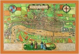
Braun & Hogenbergs Map of London 1572 (Old House) (Rolled)
Braun & Hogenberg
€ 20.99
€ 5.28
FREE Delivery in Ireland
Description for Braun & Hogenbergs Map of London 1572 (Old House) (Rolled)
Sheet map. A map of the Elizabethan London. It offers an insight into the geography of the capital and lives of its inhabitants. It features the infamous Tower of London, a bear baiting arena, the Charterhouse monastery, the monument at Chary-ncros, Old St Paul's Cathedral and even local wildlife in the grassy fields north of Holborn. Series: Old House. BIC Classification: 1DBKESL; 3JB; HBTP1. Category: (G) General (US: Trade). Dimension: 475 x 140 x 40. Weight in Grams: 46. New.
The earliest entirely extant city plan of London, this map of the Elizabethan capital was first printed in 1572. As well as being a beautiful decorative piece, it also offers an invaluable insight into the geography of London and lives of its inhabitants. It features the infamous Tower of London, a bear baiting arena, the Charterhouse monastry, the monument at “Chary-ncros”, Old St Paul's Cathedral and even local wildlife in the grassy fields north of Holborn.
The earliest entirely extant city plan of London, this map of the Elizabethan capital was first printed in 1572. As well as being a beautiful decorative piece, it also offers an invaluable insight into the geography of London and lives of its inhabitants. It features the infamous Tower of London, a bear baiting arena, the Charterhouse monastry, the monument at “Chary-ncros”, Old St Paul's Cathedral and even local wildlife in the grassy fields north of Holborn.
Product Details
Publisher
Old House Books
Publication date
2012
Series
Old House
Condition
New
Format
Sheet map
Place of Publication
London, United Kingdom
ISBN
9781908402271
SKU
9781908402271
Shipping Time
Usually ships in 2 to 4 working days
Ref
99-1
Reviews for Braun & Hogenbergs Map of London 1572 (Old House) (Rolled)
