8%OFF

Stock image for illustration purposes only - book cover, edition or condition may vary.
Children´s Wall Map of the United Kingdom and Ireland
Collins Maps
€ 9.99
€ 9.16
FREE Delivery in Ireland
Description for Children´s Wall Map of the United Kingdom and Ireland
Paperback. Colourful Illustrated Map of the United Kingdom and Ireland Illustrator(s): Evans, Steve. BIC Classification: 2AB; 4KHF; YQG; YRW. Category: (E) Primary & Secondary Education; (J) Children / Juvenile. Dimension: 915 x 610. Weight in Grams: 270.
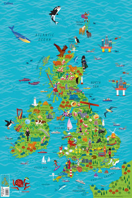
Colourful Illustrated Map of the United Kingdom and Ireland This highly illustrated, rolled pictorial map is designed to take children on a journey of discovery around the United Kingdom and Ireland. Stunning illustrations are used to depict themes such as national emblems, customs, food, birds, animals, buildings and sports to help younger readers gain an understanding of peoples around the world. ... Read more
Colourful Illustrated Map of the United Kingdom and Ireland This highly illustrated, rolled pictorial map is designed to take children on a journey of discovery around the United Kingdom and Ireland. Stunning illustrations are used to depict themes such as national emblems, customs, food, birds, animals, buildings and sports to help younger readers gain an understanding of peoples around the world. ... Read more
Product Details
Publisher
HarperCollins Publishers
Format
Paperback
Publication date
2017
Condition
New
Place of Publication
London, United Kingdom
ISBN
9780008212087
SKU
V9780008212087
Shipping Time
Usually ships in 4 to 8 working days
Ref
99-16
About Collins Maps
Steve has many years professional experience of collaborative practice with the major educational publishers, editors, in-house designers and authors. His creative practice includes illustration, logo design, cover design and full series design including online resource. ... Read more
Reviews for Children´s Wall Map of the United Kingdom and Ireland
