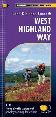
Stock image for illustration purposes only - book cover, edition or condition may vary.
West Highland Way XT40
Harvey Map Services Ltd.
€ 21.84
FREE Delivery in Ireland
Description for West Highland Way XT40
Sheet map, folded. Series: Route Map. Num Pages: 1 pages. BIC Classification: 1DBKSH; WTRM. Category: (G) General (US: Trade). Dimension: 252 x 140 x 7. Weight in Grams: 72.
Entire route on one map
One of Scotland’s Great Trails.
The West Highland Way is 153km (95 miles) from Milngavie, near Glasgow to Fort William.
Tough, light, durable and 100% waterproof
Route clearly marked
Entire route on one map
One of Scotland’s Great Trails.
The West Highland Way is 153km (95 miles) from Milngavie, near Glasgow to Fort William.
Tough, light, durable and 100% waterproof
Route clearly marked
Product Details
Publisher
Harvey Map Services Ltd United Kingdom
Number of pages
1
Publication date
2008
Series
Route Map
Condition
New
Weight
73g
Number of Pages
1
Format
Sheet map, folded
Place of Publication
Perthshire, United Kingdom
ISBN
9781851374588
SKU
V9781851374588
Shipping Time
Usually ships in 4 to 8 working days
Ref
99-3
Reviews for West Highland Way XT40
