Dredging the River

Alexander Nimmo made a survey of Lough Corrib almost two hundred years ago in which he wrote the following ; “The lake has 50 miles of shore, occupies 30,000 Irish acres and contains 1,000 acres of arable land in its isles, and contracts into a very spacious river about two and a half miles above Galway, which, flowing by the town, communicated with the Atlantic.
The fall from the summit lake to the sea is considerable, but to the Wood Quay, above the town, it is trifling, and the river is in parts very shallow, running over a bed of rocks and hard gravel. It is not navigable from the sea to the Wood Quay, owing to the shallowness and rapidity of the water, and none but small boats can come down; but, unless in very dry seasons, it is thence navigable by boats drawing four feet of water and carrying from ten to twenty tons, with one square sail and four men, to Cong. They seldom sail unless before the wind, and though the lake has many islets and sunken rocks, the only serious difficulty in navigation is at Buachally Shoal about four miles up the lake, and at Newcastle. These shoals could be deepened for a small sum and the whole made to admit vessels of much greater magnitude. This fine navigation which extends about 30 miles, and into a seaport town, seems to deserve more attention than it has yet received. A good chart with soundings and sailing directions, should be published, the shoals or rocks cleared or beaconed, and a communication opened with the sea”.
The map was duly made, and the Eglinton Canal built (though not to Nimmo’s specifications) thus providing for commercial transport to and from Galway to Cong and Maam, and from the lake to the sea.
The Salmon Weir was newly constructed in 1852 by the Board of Works for the purposes of drainage. The fishery on the river was hugely important, and was until recent times, privately owned. One of the glories of Galway was the Salmon Weir Bridge .... if you looked over it and into the river, when your eyes got used to it, you might see a salmon, and then suddenly realise that you were actually looking at a great many fish, all waiting to go up through the weir. It was a magnificent sight, and tourists flocked to see it.
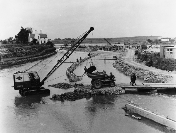
In the early sixties, it became necessary to dredge the river. It was a huge operation, and involved some complicated engineering as you can see from our photograph, and it took a long time. They had to keep diverting the flow of the river to allow cranes and diggers etc. to work on the river bed. They constructed concrete barriers like the one you see in the foreground. They obviously did it very well, you would not see a crane in the middle of the river for long today. The dredging was done over a long period, and as a result, the number of salmon going upriver was greatly reduced, and sadly, it is rare enough to see them from the bridge now.
There is scarcely a house to be seen in the background in what is Tirellan today.
Our column of February 24th, 2011 caused upset with some people. It was never intended to do so, and I apologise if it did.
Our column of February 24th, 2011 caused upset with some people. It was never intended to do so, and I apologise if it did.
TK
Please forward any queries/comments to This email address is being protected from spambots. You need JavaScript enabled to view it.
View the Old Galway Archive.