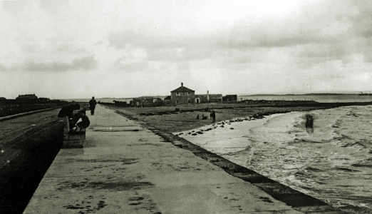
Grattan Road

by Tom Kenny
Crane’s Strand or Tráigh na gCorr appears on the 1651 map. It would seem to be the Whitestrand area before the building of Grattan Road.
In Dutton’s 1824 survey we read “It seems to be the general opinion of the oldest inhabitants that for some years past, storms and rains have been more frequent from the west than formerly. (Rice was sown here in 1585). As some corroboration of this idea, the encroachment of the sea near Recorder’s Quay on the west side of Galway, may be adduced, where the marks of the potato ridges may be seen, and where, only a few years ago were in cultivation, though they are now covered at every tide. Lately, the ground near Recorder’s Quay has been reclaimed by Mr. Bulteel, and promises to remunerate his very spirited exertion”. (Probably the first ever reclamation of land in Salthill).
On November 24th, 1863, the Galway Vindicator reported that “The completion of the Grattan Road will add much to the beauty and salubrity of the handsomest of our suburban districts. The embankment being made by Miss Grattan will reclaim 28 acres of land, which is now a swamp, but which will become, with a little cultivation, some of the most fertile ground in the neighbourhood. In the past season of distress, Miss Grattan has given great employment to the poor of that neighbourhood in making this road and embankment. Since June last, up to the present time, there has been over 200 labourers employed and from 12 to 14 masons regularly. It will, when finished, alter the appearance of Salthill, and contribute much to make that favourite watering place one of the nicest localities in the kingdom”.
This report would seem to indicate that there was general approval for the imaginative scheme of Lady Grattan’s. She was related to Henry Grattan, and she provided the funds to build Grattan Promenade, which would act as a retaining wall and hold back the sea, which until then had reached in as far as Sea Road and Nile Lodge. This project was also known as ‘The Tenpenny Road’, that being the weekly wage paid to the labourers. It was a major factor in the improvement of Salthill.
According to the Connacht Tribune of December 28th, 1928, one of the major improvements in Salthill took place in 1925-26 when a grant of £1,350 was obtained for relief work and it was spent on making a concrete promenade along Grattan Road, and steamrolling and improving the highway.
The buildings we see on the right of the road were known as Grattan Lodge or Moon’s Lodge. There was a fenced in vegetable garden on the seaside of the building. In February 1957, there was a violent storm which destroyed the contents of the Lodge which by then had been converted into four houses. The high sandbank at the seaward side of the houses collapsed and the sea came in through the windows in torrents. Furniture floated out through windows on the other side. The following morning, mattresses, armchairs and bedsteads were lying askew outside the houses, half covered in sand. The families all had to spend the night with friends. Grattan Road had collapsed in two places and the water mains were severed. South Park resembled a lake, along the Frenchville part of the road the houses were flooded to a level of four feet and the road surface was littered with stones, sand and mud. Fires were extinguished by the rising waters. In the docks, five boats were lifted out of the water and were stranded high and dry on the quayside.
