THE LOCK KEEPER’S HOUSE
by Tom Kenny
The Eglinton Canal was a work of great utility both in terms of draining and regulating the surplus waters of the lake and permitting ingress from the sea. The lower lake used to empty it’s waters through a delta by three visible outlets into the sea; The natural and original shallow tortuous and rocky Galway River, navigable only for very small craft and row-boats; The Mionlach creek, a small stream nearly filled up; “The Friar’s Cut”, about three quarters of a mile in length, fifty feet wide and twelve feet deep.
In 1848, the Board of Works started on a project to improve the drainage, navigation and water power in connection with the lake and river. They built Steamer’s Quay, a regulating weir, built up the walls along the river bank, dredged the river, constructed the Eglinton Canal and the Claddagh Basin, mill races, tail races and bridges over the canal. All of the bridges were swivel bridges, and could be operated by hand so as to allow navigation through.
These works resulted in the lake being lowered by three feet and the rise and fall between summer and winter being limited to three feet which relieved a lot of flooding in the surrounding lowlands. The summer level of the lake is 14 feet above that of the high water of ordinary high tides in the bay. The river is about 4 miles in length.
Over many centuries, there had been plans to connect the lake and the sea, but none of them came to any fruition. The last plan was devised by Alexander Nimmo, his idea was to start the canal where McSwiggans is today, run it along Eglinton Street and down the west side of Eyre Square to the docks. This met with a lot of opposition from landowners and businesses along the way. So, it was decided to go the Eglinton Canal route and the cutting of the canal began in March, 1848.
It provided much needed work and relief during the Famine. The filling they dug out was used to fill the terraces in UCG and also to fill in the causeway behind Claddagh Quay. The canal is two thirds of a mile long with a depth of navigation of six and a half feet. It provided a feeder channel to the Gaol River, the Western River and the various mills they helped to power. All of the work had to be done in a way that had no detrimental effect on the mills or fishery interests. The ascent from the lake to the sea was accomplished by one lock, 130 feet long and 21 feet wide, with a lift of about 14 feet.
The Claddagh Basin was constructed to cater for the 300 boats being operated by Claddagh fishermen at the time. A lock was built between the Basin and the sea.
Initially, the canal was a big success commercially and the tolls collected were significant. In 1880, £370 was collected. In 1904, 3,194 tons were carried through the canal and the revenue was £992. The following year, in addition to passengers, coal, meal, flour bran, grain, manures and timber were carried. The waterway was in good condition but there was concern about a sufficient depth of water for the type of steamer in use. By 1915, there was almost no commercial traffic on the canal as apathy, neglect and drainage problems reduced its value. In 1954, the bridges were examined and found to be in a dangerous state and so were replaced by fixed bridges. This meant the end of commercial traffic on the waterway.
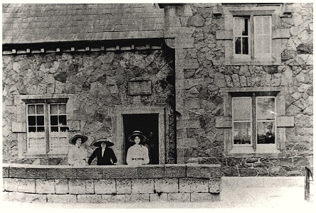
As described, there was one lock on the canal at Parkaveara and so a stone house was built at Ballsbridge, the bridge at Dominick Street, for the lockkeeper. This house was constructed in 1852 and was occupied by the first lock keeper, John Keogh, whose annual salary was £45. 12. 6. Some years later, John Fleming took over the job and the house and he lived there with his family. Our first photograph was taken in 1906 and shows John’s wife Mary dressed in black in front of the house with a young lady on either side. John died in 1917 and Mary in 1948. Both are buried in Forthill. The building was later occupied by the National Bank and the Bank of Ireland.
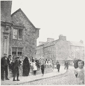
Our second image was taken about the same time and shows the gable of the house with the little wall in front. To the right you can see the bridge and part of Lower Dominick Street.