GRATTAN ROAD BUILDINGS
by Tom Kenny
The Galway Vindicator of November 24th, 1863 reported that “The completion of the Grattan Road will add much to the beauty and salubrity of the handsomest of our suburban districts. The embankment being made by Miss Grattan will reclaim 28 acres of land, which is now a swamp, but which will become, with a little cultivation, some of the most fertile ground in the neighbourhood. Miss Grattan has given great employment to the poor of the neighbourhood in making this road and embankment. Since June last, up to the present time, there has been over 200 labourers employed and from 12 to 14 masons regularly. It will, when finished, alter the appearance of Salthill and contribute much to make that favourite watering place one of the nicest localities in the kingdom”.
Miss Grattan was a relation of Henry Grattan. The project was known as ‘The Tenpenny Road’ as that was the weekly wage paid to the labourers. It was a major factor in the improvement of Salthill, indeed it was the first time land was reclaimed in the area.
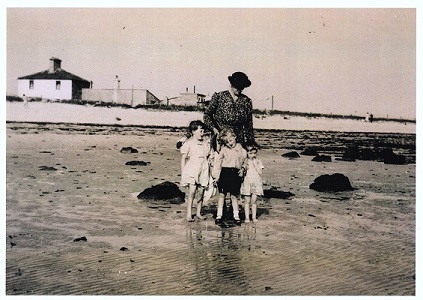
Lady Grattan provided the funds to build the Promenade so they named it after her. It would act as a retaining wall to hold back the sea, which, until then had reached in as far as Sea Road and Nile Lodge. Our first photograph shows Helen, Pádraic and May Spellman with their aunt Mary Anne McDonagh on Grattan Beach. Mary Anne had a shop on Forster Street. The building behind them was known as Grattan Lodge or Moon’s Lodge. It was built and occupied by Alexander Moon. There was a fenced off vegetable garden on the sea side of the buildings. In February, 1957, a very violent storm destroyed the contents of the Lodge, which by then had been converted into four houses .The high sandbank on the seaward side of the houses collapsed and the sea came through the windows in torrents. All of the furniture was left lying askew outside, half covered in sand.
Grattan Road had collapsed in two places and the water mains were severed. South Park resembled a lake and all along the Frenchville part of the road, the houses were flooded to a level of four feet. The road surface was littered with stones, sand and mud. Fires were extinguished by the rising waters. After Hurricane Debbie in 1961, Grattan Lodge had to be demolished. There is no trace of it left.
Today, the little peninsula is a small park known as “The Celia Griffin Children’s Park” which also includes “The Mutton Light Famine Memorial”.
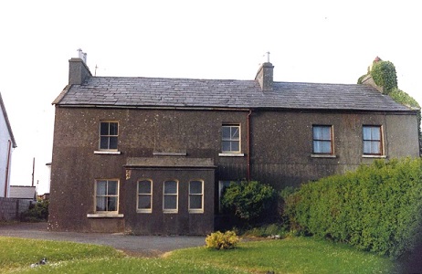
Our second illustration is of White Strand Lodge which appeared on the 1838 map. It was eventually divided into two houses. The one on the left was occupied by the Walsh family, the one on the right originally by the postmaster William Cornwallis and later by the O’Halloran family. Walter Macken lived in this house for a time in the forties. The lane from outside the house ran down from Grattan Road and to the left of the houses, it forked with one section going up to Nile Lodge. This section was known as Trim’s Lane or Strand Lane and was sometimes referred to as McGinty’s Lane. To the right of this section of the lane was the Bull’s Field which was often liable to flooding and also the Monk’s Field which was just behind the beginning of Father Griffin Road. On the left of this section was land owned by the Brothers.
The other section of the lane turned right at the fork towards Father Griffin Road. This was known as Lover’s land or the ‘Bockety Lane’ sometimes known as the ‘Bockatees’. To the left of this section was a field known as ‘The Plots’ which contained a well and a circle of trees which may once have been a ring fort. The gate into the field was known locally as ‘The Coortin Gate’.
The entire lane was invariably covered in fine white sand. The area behind White Strand Lodge was known locally as ‘The Boggers’.
Our thanks to Patricia O’Halloran Fox for her help with this article.