Old Galway
A CHRISTMAS CARD FROM SALTHILL, 1920

by Tom Kenny
As the War of Independence hotted up, the British Authorities sent the Black and Tans and the Auxiliaries to Ireland to support the RIC. D Company of the Auxiliaries was stationed at Lenaboy Castle and at ‘The Retreat’ in Rockbarton.
Their first commander, A.P. Nichol was quoted as saying “We are the auxiliary force and act independently. All our men are ex-officers and, I hope, gentlemen. I wish it to be strictly understood that we are not here to shoot people, but to restore order. We are obliged to take certain steps to do this, peaceable and law abiding citizens have nothing to fear from us”. Nichol was dismissed on November 30th, 1920 for excessive drinking.
Devon Park, a brief history
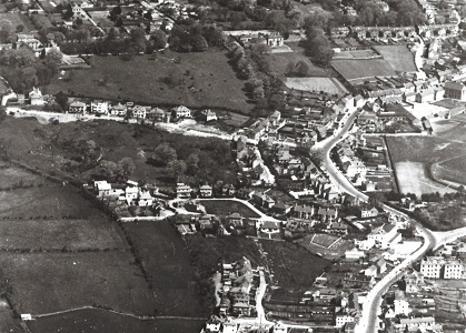
by Tom Kenny
The area we know as Devon Park in Salthill was originally part of the Lenaboy estate which belonged to the O’Hara family, who were based in Lenaboy Castle. The entire left hand side of our aerial photograph (c.1940 ) was part of the estate, originally a green field site, the outer wall of which ran along the main Salthill Road. Bertie Simmons knocked part of that wall in the early 1930s and built two houses, one at the corner (where the fish shop is today ) and one behind it where Hartigans lived.
Merlin Park House
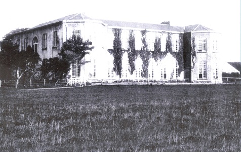
by Tom Kenny
The Blake family started work on the construction of Merlin Park House in 1808 and it was completed in 1812. It cost £12,000 to build and provided much needed employment for many local skilled workers and labourers. Getting materials to the location proved difficult – it was said that more than 40 mules were used to transport goods and building materials from Galway to the site.
The house was described as “A long two storey house consisting of six bays and two 3-sided bows” standing on 1,109 acres, three roods, and eight perches. The estate consisted of 224 acres of arable land, five acres of roads and drives, four acres of gardens and orchards, all surrounded by a wall over 15 feet high, and more than 100 acres under plantation.
THE GALWAY MECHANICS’ INSTITUTE 1838-1918

by Tom Kenny
Mechanics’ Institutes originated in Scotland in the 1820’s. In 1826 a committee formed the first such Institute in Galway when a committee set out a library and newspaper reading room in the ballroom of the Corn Exchange in Eyre Square. Their primary aim was educational and they had rules prohibiting discussion of politics and religion. Difficulties arose when some of the patrons of the facility presumed they could tell the members how to vote in an election and so the institute collapsed.
PALACE OF DREAMS
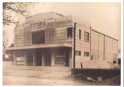
by Tom Kenny
Eighty nine years ago this week, on November 22nd, 1939, the Estoria Cinema opened at Nile Lodge. It had 776 seats and two showings a night at 6.45 and 8.45pm. It cost two shillings to sit in the balcony and the prices for the parterre were 1/4 and 9d (including tax). There were matinees on Thursdays (half day in Galway), Saturdays and Sundays. You could book at the cinema or by phone (Galway 101) from 12 noon to 2pm and from 6pm. The building was constructed by John McNally & Co. with John Connolly as foreman. The design was by Hubert O’Connor and Ralph Ryan was the electrical consultant.
GALWAY CRYSTAL

by Tom Kenny
In 1967, a meeting of Junior Chamber in Galway was discussing ways of creating employment in Galway, when Thomas McDonogh mentioned that he could not get Waterford Crystal to supply his shop in Merchant’s Road, so a number of the members decided to set up their own crystal factory. These were Thomas McDonogh, Seamus Kavanagh, Dermot McLoughlin, Charley Garavan, Joe Heskin, John Holland and Jack Toolan. Their average age was 29. They bought some cutting machinery and set up in a small garage, what is now Kilduff’s Motor Repair shop in Nun’s Island.
Galway and the Great War 1914-1918

by Tom Kenny
On August 4th 1914, Lt Col Henry Jourdain, Commander of the Connaught Rangers in Renmore Barracks, Galway, received mobilisation orders which changed the lives of thousands of families throughout the city and county. Urgent appeals for recruits were sent out. Hundreds of young men began arriving from all over Connacht. Temporary military camps were set up outside the barracks to cater for the recruits.
SALTHILL CITIZEN’S ASSOCIATION

by Tom Kenny
The first concerted move to improve Salthill (that I know of) was in 1882 when funds were collected locally and the Salthill Improvement Company was set up to improve the resort. The prevention of pollution was a priority. The company had its ups and downs and eventually died off. The first meeting of the Galway Urban District Council in 1925 had a deputation from Salthill who listed proposed improvements, In the 1930’s a Salthill Development Committee was set up.